Once every well sits in one layout, the weeks of gathering and reformatting disappear and the question itself gets the time. Here is what we've built on it so far.
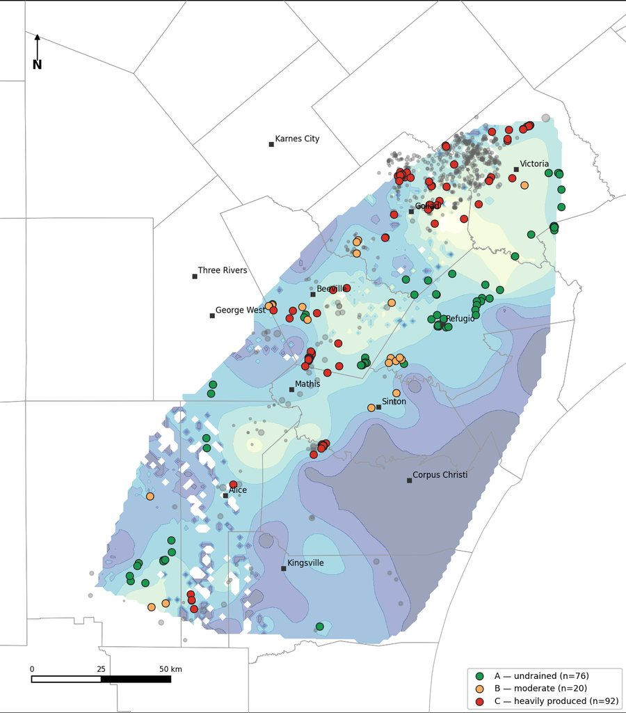
Fresh water from wells already drilled Corpus Christi, Texas
In January 2026 the two reservoirs that serve Corpus Christi and the Coastal Bend fell to 10% of combined capacity, the lowest in their history. The usual answers, desalination plants and new wellfields, take years and hundreds of millions of dollars.
We asked a faster question: which wells already in the ground could be put to work for water? Decades of oil and gas drilling have left thousands of wellbores through the Gulf Coast aquifers. Some of them reach good water sand that nobody is pumping.
We joined Texas oil and gas well records with state water well records, plugging reports and borehole logs, mapped the usable-quality sand in the Chicot, Evangeline and Jasper aquifers, and screened every wellbore that reaches it: is it unplugged, is it deep enough, is it open to the sand, and is anyone nearby already drawing down that water?
The study is in review with people who know the region's water best. If you work on water supply in South Texas, ask us about it.
Wellbore diagrams from public well files Colorado
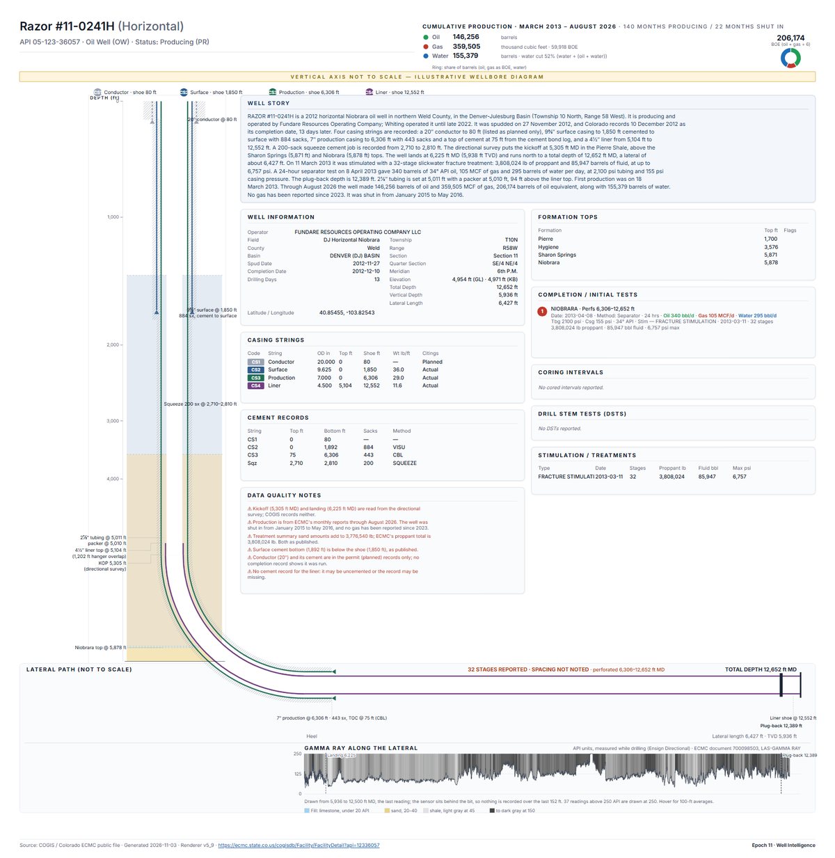
A state's well files hold everything needed to draw a wellbore: casing strings, cement, perforations, the kickoff point, the lateral, the logs and the production history. They're just scattered across scanned forms, tables and log files.
We pull it together into one page. Our first is Razor #11-0241H, a 2012 horizontal Niobrara oil well in northern Weld County, in the Denver-Julesburg Basin. The page shows the casing and cement around the curve, the 6,427-foot lateral with the gamma ray log recorded while drilling, every month of production since 2013, and the directional survey.
We draw only what the records show. The completion report gives 32 fracture stages but not where they are, so the page says exactly that instead of inventing a spacing. Where records disagree or are missing, the page tells you.
Open the Razor #11-0241H wellbore page. We're building these for Colorado first, from old vertical wells to horizontal wells.
Orphan wells United States and Canada
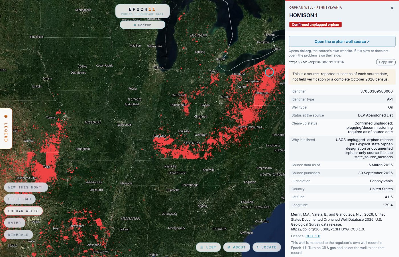
An orphan well is an oil or gas well left unplugged with no company responsible for it. Unplugged wells can leak methane into the air and let brine or gas into groundwater, and plugging them falls to the public.
The lists exist, but they are kept apart from the well records. We put the United States Geological Survey's Documented Orphaned Well Database and the Saskatchewan and British Columbia orphan inventories on the same map as every other well. On the map, turn on Orphan wells and turn the other layers off to see them alone. For reporters covering methane and climate, and for landowners who want to know what is left in the ground near them.
Each orphan opens to its source record. Where the regulator's current status disagrees with the orphan list, the well's card shows both, with their dates, and says either may be out of date. The lists are what each source reports, not a field survey.
Open the map and turn on Orphan wells.
What's active around me? Coming soon
Every well record has a place on the map, so the question can start from where you are: your land, your water well, your mineral rights.
Landowners
Reports on the active oil, gas and water wells around you, and new drilling permits as the agencies issue them.
Water well owners
Why is my well running dry? See who else draws on your aquifer nearby, how deep they pump, and how water levels have changed where records exist.
Mineral owners
What's being drilled near your minerals, who operates it, and what the wells nearby have produced.
Want to know when this is ready? Tell us where you are.
Your project
Prospecting, water supply, orphan wells, carbon storage, geothermal, teaching: if the records could help, tell us what you're working on. The cleaned data is free to download wherever the agency's licence allows it.